Published: Apr 23, 2026
One AI model replaced twelve - cutting land inspection time by 87.5% for a major water utility
One AI model replaced twelve - and cut land inspection time by 87.5%
For one of Victoria's leading water utilities, managing thousands of kilometres of remote terrain meant relying on drone surveys and expert reviewers to spot hazards like fallen trees, broken fences, and invasive weeds. The problem wasn't capturing the images; it was making sense of them. Each batch of 1,000 drone photos required up to 40 hours of specialist review, trapping skilled staff in repetitive work rather than in remediation and planning. NCS proved that a single generative AI model could do what twelve separate machine learning models could not: detect, interpret, and contextualise land defects in one pass, reducing review time to five hours and projecting annual savings exceeding AUD $100K.
Key takeaways
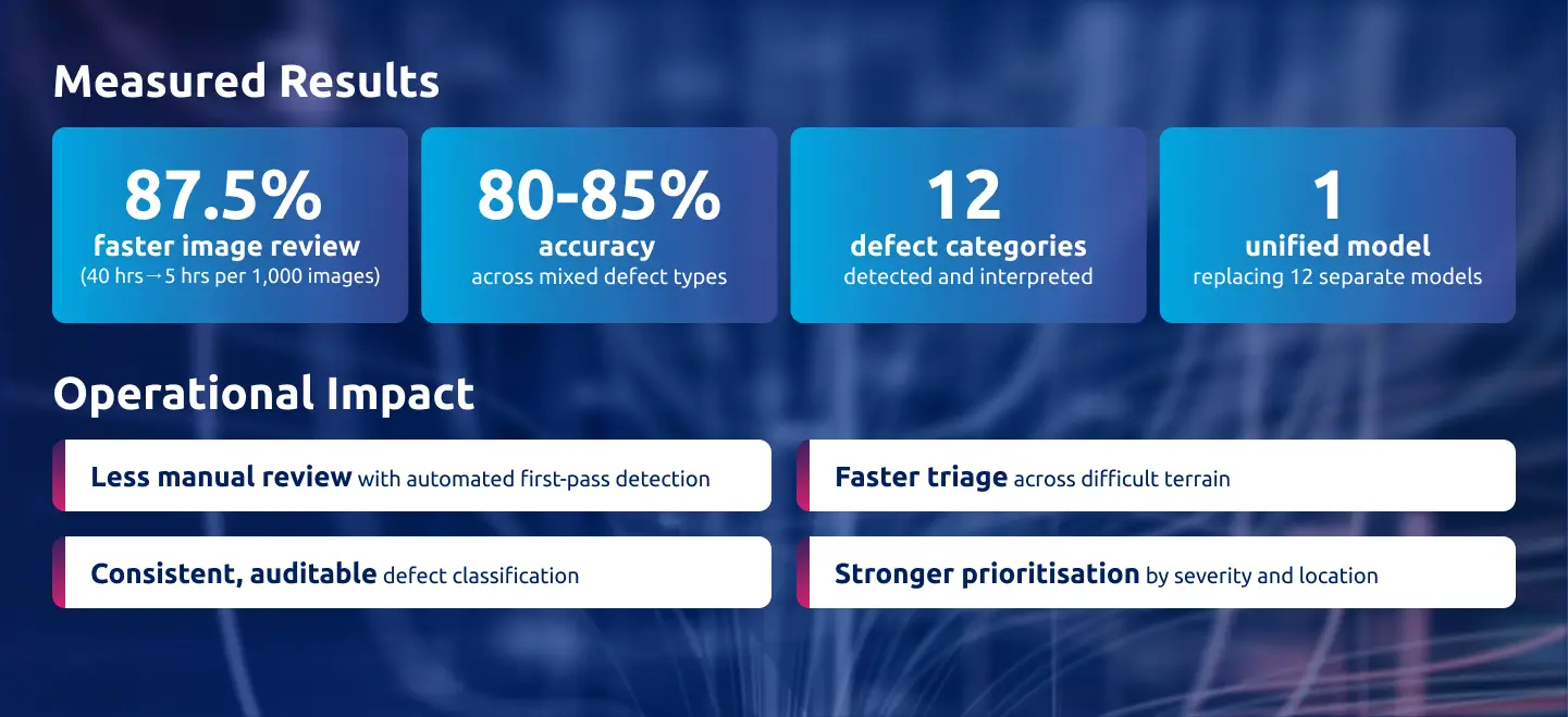
- Image review time reduced by 87.5%, from 40 hours to five hours per 1,000 drone images, with projected annual savings exceeding AUD $100K.
- A single generative AI model replaced the need for twelve separate machine learning models, detecting all defect categories in one pass with human-level contextual judgement.
- Detection accuracy reached 80–85%, surpassing the initial 70% target, with structured outputs including GPS coordinates for immediate field action.
- The proof of concept was delivered in just two weeks using Azure-native architecture (GPT-4o on Azure AI Foundry), integrating into existing workflows via Excel and Power Apps.
- The client is now building a business case to transition from POC to full-scale production, with the framework applicable across energy, transport, agriculture, and infrastructure.
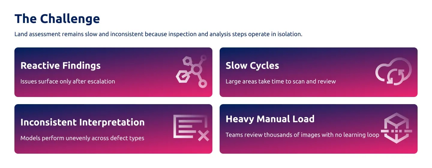
The problem: thousands of images, no way to scale expert review
Effective land management is a core operational responsibility for water utilities managing vast, often inaccessible terrain. Manual field visits and visual inspections were slow, inconsistent, and difficult to standardise across remote sites. Drone surveys solved the visibility problem - high-resolution aerial imagery gave teams coverage they had never had before, significantly improving both safety and reach.
But drones created a new bottleneck. Every image still required expert review. Teams were scanning thousands of photos to identify issues such as fallen trees, broken fences, cattle incursions, erosion, and invasive weeds. At up to 40 hours of specialist effort per 1,000 images, skilled staff were stuck in repetitive review cycles rather than focusing on remediation, planning, and higher-value work.
The utility spent over a year exploring technology solutions, but nothing delivered automation at scale with the contextual judgment the work demanded. Traditional machine learning models could detect predefined objects, but they could not interpret what they were seeing. They struggled to tell natural vegetation from an encroachment hazard, or to recognise subtle patterns that only an experienced human reviewer would catch.
The breakthrough: one model, twelve defect types, human-like judgement
NCS initially explored building separate machine learning models for each of the twelve defect categories. This approach quickly hit its limits — issues such as vegetation encroachment and invasive weed growth required contextual interpretation that traditional models could not provide.
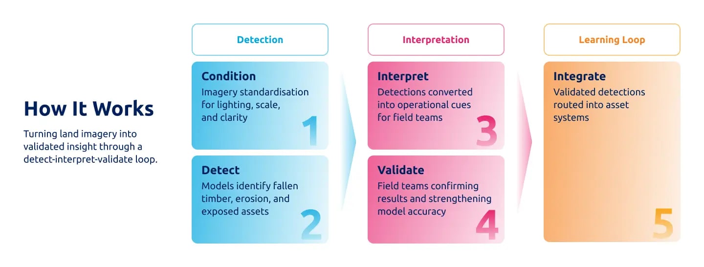
The breakthrough came from a simpler, more powerful idea: using a single generative AI model to detect multiple issues in one pass while interpreting context with human-like judgment. Built as a fully Azure-native proof of concept, the solution was delivered in just two weeks. It could analyse thousands of drone images in bulk, detect and interpret all twelve defect types, generate structured outputs with GPS coordinates for operational action, and integrate into existing workflows via Excel or Power Apps.
What set the project apart was the human-first approach. Before development began, NCS spent time with the client's field and review teams to understand their workflows, challenges, and decision-making processes. These insights informed every design choice. Throughout the development process, successes and setbacks were shared openly. The client was involved early, and teams experienced the model's capabilities first-hand, building trust, accelerating adoption, and strengthening stakeholder advocacy.
The results: faster reviews, freed-up experts, and a path to production
Even at the proof-of-concept stage, the impact was transformative. Image review time improved by 87.5%, reducing the time from 40 hours to 5 hours per 1,000 images. Detection accuracy reached 80–85%, exceeding the initial 70% target. Projected annual savings exceed AUD $100K, and that is before full-scale deployment.
Beyond the numbers, the real shift was felt in day-to-day operations. Expert capacity was unlocked, enabling specialists to focus on problem-solving and remediation instead of repetitive scanning. Early adopters within the client organisation became vocal champions for scaling the solution. The move from manual strain to intelligent support was visible and immediate, reinforcing confidence in the value of AI across the organisation.
The POC has been successfully delivered and well received by key stakeholders, confirming both feasibility and value. The client is now developing a business case to transition to full-scale production.
From proof of concept to scalable land intelligence
This project demonstrates what happens when AI is designed to think in context rather than just detect in isolation. By replacing twelve narrowly trained models with a single generative AI system capable of human-level interpretation, NCS turned an unsustainable manual review process into a scalable, accurate, and operationally integrated land intelligence capability in two weeks.
This is not just a faster image review. It is a blueprint for applying contextual AI to any operation where expert judgement is the bottleneck. Any domain that requires AI to look, recognise, and understand at scale — energy, transport, infrastructure inspection, agriculture, environmental monitoring, and insurance — can benefit from the same approach.
For organisations sitting on growing volumes of visual data with no way to process it efficiently, this is the shift from reactive inspection to proactive land management.